4) Qualitative Validation of Meteorological Results Based on Soot Patterns and Oil Well Fire Plumes. Due to the lack of data collected on-site, analysts predicted meteorological fields and agent concentrations cannot be directly compare with observations. However, several sources of imagery data, including soot patterns created by the March 10 bunker explosions at Khamisiyah and regional-scale imagery of the Kuwait oil-field fire plumes, are available for March 10-11, 1991, to provide a basis for a qualitative comparison.
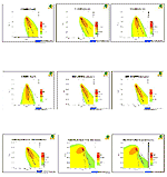
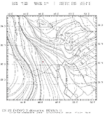
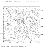
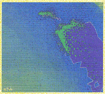
Based on the April 27, 1991, Satellite Pour l'Observation de Terre (SPOT) photography (Figure A-39) of distinct trails of wind-blown soot patterns resulting from a bunker demolition occurring around the same time as the Khamisiyah Pit explosions, the surface wind direction was approximately 335°, thus blowing any chemical warfare agent released to the south-southeast. The one standard-deviation spread of the 14 vectors derived from the soot trails of the 124 bunkers was 10°. The azimuths' consistency within the 3.4 km spread of the destroyed bunker area reasonably suggests the wind direction information for the Pit area, which was approximately 2 km from the southern end of the demolished bunkers. For this simple case of straight-line, short-range transport, HPAC/SCIPUFF was run with nine mesoscale meteorological fields described above, and the corresponding predicted chemical warfare agent contours were compared to the calculated soot-direction vector emanating from the Khamisiyah Pit location (Figure A-40). Model comparisons were quite similar for most runs.
Figure
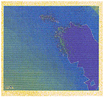
A-39. SPOT imagery of soot patterns at Khamisiyah
Figure A-40. Meteorological experiments for Khamisiyah soot patterns predicted by HPAC/SCIPUFF
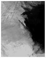
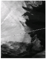
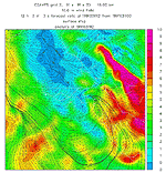
Figures A-41 and A-42 show the satellite images of the smoke dispersion patterns from the Kuwait oil fires on March 10 and 11, 1991, respectively. The influence of vertical wind shear is evident with the transport of the contaminant in the PBL and in the free troposphere heading in different directions. For the oil well fire simulations, HPAC/SCIPUFF was initialized as a vertical line source extending from the surface to 1500 m. Then simulations were performed using nine meteorological data fields described above. Most of the resulting trajectories capture the general characteristics of a largely bi-directional transport because of vertical wind shear.
Figure
A-41. Satellite imagery of oil-fire plumes,
March 10, 1991
Figure
A-42. Satellite imagery of oil-fire plumes,
March 11, 1991
Based on the above qualitative comparison, the DoD modeling team chose NOGAPS/COAMPS
Experiment 4, GDAS/OMEGA Run k10y, and ECMWF/MM5 as the baseline meteorological
simulations for the dispersion calculations because these simulations appeared
to predict most consistently the observational phenomena considered.
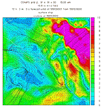
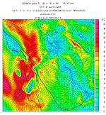
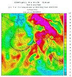
5) Description of Baseline Mesoscale Flow Fields. This section discusses the 1997 COAMPS 15 km (Grid 2), the MM5 10 km (Grid 2), and the OMEGA result for 1200 UTC March 10 through 1200 UTC March 13, 1991. The COAMPS, MM5, and OMEGA mesoscale near-surface wind flows (Figures A-43, A-44, and A-45) in the Khamisiyah area just before the release (1200 UTC March 10) resemble the synoptic flow pattern (shown in Figure A-29) and are all characterized by north-northwesterly, low-level flow driven by the local ridge tracking the low-pressure region moving eastward across Iran (shown in Figure A-28).
Figure A-43. COAMPS Grid 2 wind fields forecast for 1200 UTC, March 10, 1991
Figure
A-44. MM5 Grid 2 wind fields forecast for 1200 UTC, March 10, 1991
Figure A-45. OMEGA wind fields forecast for 1200 UTC, March 10, 1991
Over the next 24 hours (1200 UTC March 10 to 1200 UTC March 11, 1991), the COAMPS
and MM5 analyses indicate the low-level wind flow in the Khamisiyah area and,
just to the south, shifts from northwesterly to east-northeastly as the low-pressure
over Iran weakens (Figures A-46 and A-47).
Figure A-46. COAMPS Grid 2 wind fields forecast for 1200 UTC, March 11, 1991
Figure A-47. MM5 Grid 2 wind forecast for 1200 UTC, March 11, 1991
Over the next 24 hours (1200 UTC March 11 to 1200 UTC March 12, 1991), the shallow
surface low southwest of Khamisiyah and the strong high pressure system over
Iran and the vicinity of the Arabian Gulf (Figure A-33)
are the dominant low-level features in the region. The resulting intensification
of the low-level pressure gradient over the Khamisiyah region drives the mesoscale
flow patterns and shifts the winds to the south-southeast (Figures
A-48 and A-49).
Figure A-48. COAMPS Grid 2 wind fields forecast for 1200 UTC, March 12, 1991
Figure A-49. OMEGA wind fields forecast for 1200 UTC, March 12, 1991
Over the third 24 hours of the reanalysis period (1200 UTC March 12 to 1200
UTC March 13, 1991), a surface low over central Saudi Arabia moves northeastward
into northern Saudi Arabia and southern Iraq, establishing a prominent low-level
feature in the region (Figure A-35). The low-level
mesoscale wind flow exhibits weak cyclonic circulation, driven by the surface
low with generally north-northeasterly flow at Khamisiyah, shifting cyclonically
to southerly south of Khamisiyah (Figure A-50). Stronger
southerly winds are evident near the Arabian Gulf.
Figure A-50. COAMPS Grid 2 wind fields forecast for 1200 UTC, March 13, 1991